Freezing Rain vs. Sleet vs. Snow: How Ice Storms Form and Why They Are So Dangerous
- Snow stays at or below 32°F all the way down; sleet partly melts and refreezes into pellets; freezing rain melts fully and freezes on contact.
- A warm layer aloft over shallow cold air at the surface is what produces sleet and freezing rain.
- The NWS usually issues an Ice Storm Warning for about 1/4 inch of ice or more.
- The Sperry-Piltz Ice Accumulation Index rates ice damage from 0 to 5; wind sharply increases damage.
- Hail forms in thunderstorm updrafts, not winter storms, so it is not the same as sleet.
- Freezing rain vs. sleet vs. snow: the short answer
- How a warm layer aloft decides what falls
- What is freezing rain and why is it so dangerous?
- What is sleet, and is sleet or freezing rain more dangerous?
- Sleet vs. hail: not the same ice
- Ice storms: how much ice is a problem?
- The Sperry-Piltz Ice Accumulation Index (SPIA)
- Driving on freezing rain, sleet and black ice
- How to read a mixed-precipitation forecast
This article is part of the 77.today Winter Weather Guide 2026–27, prepared by the 77.today editors from the sources listed at the end.
Snow, sleet and freezing rain can all fall from the same storm within a few miles of each other, and they can look similar on a radar app. They are not the same thing. The difference comes down to a layer of warm air a few thousand feet up and how thick the cold layer below it is. This part of our Winter Weather Guide 2026–27 explains freezing rain vs. sleet (two of the most searched winter weather questions in the United States), how each forms, why freezing rain causes ice storms, how forecasters rate ice damage with the Sperry-Piltz Ice Accumulation Index, how sleet differs from hail, and how to drive when the roads glaze over.
Freezing rain vs. sleet vs. snow: the short answer
All three usually start the same way: as snowflakes high in a cloud. What happens next depends on the temperature of the air they fall through on the way down. NOAA's National Severe Storms Laboratory (NSSL) describes the three paths like this:
- Snow: the temperature stays at or below 32°F (0°C) from the cloud base to the ground, so the flakes never melt.
- Sleet: the snowflakes partially melt in a warm layer, then refreeze into ice pellets before reaching the ground.
- Freezing rain: the snowflakes melt completely in a warm layer, then fall through a thin layer of freezing air near the surface that is too shallow to refreeze them. The drops become "supercooled" and freeze instantly when they touch anything at or below 32°F, creating a glaze of ice.
| Snow | Sleet | Freezing rain | Hail | |
|---|---|---|---|---|
| What falls | Ice crystals (flakes) | Ice pellets | Supercooled liquid drops | Balls or lumps of ice |
| How it forms | Stays at or below 32°F from cloud to ground | Melts in a warm layer, refreezes in a deep cold layer before landing | Melts completely, then freezes on contact with surfaces at or below 32°F | Raindrops carried up by thunderstorm updrafts freeze and grow |
| Season | Winter | Winter | Winter | Mostly spring and summer thunderstorms |
| Sound and look | Quiet, piles up white | Pings off windows, bounces | Looks like rain, leaves a clear glaze | Falls from thunderstorms, can be large |
| Main danger | Visibility, heavy snow loads, slick roads | Very slick roads, heavy to shovel | Ice on roads, trees and power lines | Damage to cars, roofs, crops |
Look at what hits your windshield. Snow arrives as flakes. Sleet bounces as tiny ice pellets. Freezing rain arrives as ordinary-looking rain and turns to clear ice the moment it touches the glass, the road or a tree branch. Of the three, freezing rain is the one that causes ice storms and long power outages.
How a warm layer aloft decides what falls
Picture the atmosphere above your house as a stack of layers. In a typical winter storm, warm, moist air from the south rides up and over shallow cold air that is hugging the ground. This creates a "warm nose": a layer above freezing sandwiched between cold air in the cloud and cold air at the surface.
The thickness of each layer decides the outcome. If there is no warm layer, you get snow. If the warm layer is shallow, flakes only partly melt and the deep cold layer below refreezes them into sleet. If the warm layer is deep enough to melt the flakes completely and the cold layer near the ground is thin, the drops do not have time to refreeze and you get freezing rain. If the surface layer is also above freezing, it is just rain.
That is why the rain-snow line in a winter storm is rarely a line. It is a band with snow on the cold side, a mix of sleet and freezing rain in the middle, and rain on the warm side. A shift of a few degrees in the warm layer can move that band across a whole metro area, which is why forecasts for mixed precipitation change so often in the final 24 hours.
What is freezing rain and why is it so dangerous?
The NWS defines freezing rain as rain that freezes when it hits the ground, creating a coating of ice on roads, walkways, trees and power lines. From the window it can look like an ordinary cold rain. The giveaway is what it leaves behind: a clear, glassy glaze that thickens with every hour of rain.
Freezing rain is dangerous for three reasons. First, the ice is often invisible on dark pavement. Second, ice adds weight to everything it coats. Tree branches and power lines are designed for wind and their own weight, not for a heavy shell of ice, and they start to snap once the glaze gets thick, especially if the wind picks up. Third, ice storms tend to cover wide areas, so utility crews may face thousands of broken lines at once. According to the NWS, heavy ice can bring down trees, topple utility poles and communication towers, and disrupt power and communications for days.
A related hazard is freezing drizzle: very small supercooled drops that fall from shallow clouds. Freezing drizzle rarely builds thick ice, but it can glaze roads quickly and catch drivers off guard because the sky does not look stormy.
What is sleet, and is sleet or freezing rain more dangerous?
Sleet is made of ice pellets: small, translucent balls of ice that bounce when they hit the ground and make a ticking or pinging sound on windows and car roofs. The NWS adds that sleet causes moisture on roads to freeze and become slippery.
People often ask whether sleet or freezing rain is more dangerous. For power lines and trees, freezing rain is far worse, because sleet does not stick to branches and wires the way a glaze does. On roads, both are treacherous. Sleet piles up like coarse sand and can be packed by traffic into a solid sheet, while freezing rain coats everything in clear ice. A storm that changes from sleet to freezing rain is the worst of both: a layer of pellets underneath a glaze.
A practical tip: sleet is very heavy to shovel compared with fluffy snow, so clear it in stages and take breaks. Overexertion while shoveling is one of the winter risks the government's ready.gov site specifically warns about (see our winter storm preparedness checklist).
Sleet vs. hail: not the same ice
"Sleet vs. hail" is searched almost as often as "freezing rain vs. sleet," and the confusion is understandable because both are balls of ice. They form in completely different ways. According to NSSL, hail forms inside thunderstorm updrafts: raindrops are carried upward into extremely cold parts of the storm, freeze, and grow as more water freezes onto them, until the updraft can no longer hold them up. Sleet forms in winter storms when snowflakes partly melt and refreeze on the way down.
So the season is usually the clue. Ice pellets falling on a cold, gray January day are sleet. Ice falling from a spring or summer thunderstorm, sometimes golf-ball sized or larger, is hail. Small, soft, white pellets that crumble when squeezed are a third thing, called graupel, which forms when supercooled droplets freeze onto snowflakes.
Ice storms: how much ice is a problem?
An ice storm is a storm with significant freezing rain. The NWS usually issues an Ice Storm Warning for ice accumulation of around 1/4 inch or more, an amount it says will make travel dangerous or impossible and will likely lead to snapped power lines and falling tree branches. Lighter icing usually falls under a Winter Weather Advisory.
For 2026–27 there is one important change. The NWS said in Service Change Notice 26-52 that, on or about October 1, 2026, it would begin using "Particularly Dangerous Situation" wording in selected Ice Storm Warnings (and Blizzard Warnings) when it has high confidence in an event "of extreme and historic severity." If you see that phrase, expect a long outage and prepare accordingly.
Ice storms are not limited to the far north. The January 2009 ice storm that first put the SPIA index (below) to the test hit Oklahoma and Arkansas, and the NWS stresses that even small ice amounts are dangerous anywhere. In Chicago, the NWS measured 0.44 inch of ice at O'Hare International Airport during the February 11–12, 2019, ice storm, followed by strong winds.
The Sperry-Piltz Ice Accumulation Index (SPIA)
Because ice damage depends on wind as much as on ice thickness, forecasters in parts of the country use a dedicated scale. The Sperry-Piltz Ice Accumulation Index, or SPIA Index, was introduced in 2007 by Sidney Sperry of the Oklahoma Association of Electric Cooperatives and Steven Piltz, then meteorologist-in-charge of the NWS office in Tulsa. It rates expected damage to overhead utility systems from 0 to 5, a little like the hurricane wind scale, using forecast ice accumulation, wind and temperature. It was first used formally by NWS Tulsa ahead of the January 26–28, 2009, ice storm in Oklahoma and Arkansas, when a Level 5 event was forecast at least three days in advance.
Here is a simplified version of the published scale (radial ice is the thickness of ice around a wire or branch):
| SPIA level | Example ice and wind combinations | Expected impact |
|---|---|---|
| 0 | Under 1/4 inch of ice with winds under 15 mph | Minimal risk to utility systems; few outages |
| 1 | 0.10–0.25 in with 15–25 mph winds, or 0.25–0.50 in with light wind | Isolated outages lasting a few hours; slick roads and bridges |
| 2 | 0.25–0.50 in with 15–25 mph winds, or 0.50–0.75 in with light wind | Scattered outages typically lasting 12 to 24 hours |
| 3 | 0.50–0.75 in with 15–25 mph winds, or 0.75–1.00 in with light wind | Numerous outages, excessive tree limb damage, outages of 1 to 5 days |
| 4 | 0.75–1.00 in with 15–25 mph winds, or 1.00–1.50 in with light wind | Widespread damage including some transmission lines; outages of 5 to 10 days |
| 5 | 0.50–0.75 in with winds over 35 mph, or more than 1.5 in of ice | Catastrophic damage; outages could last several weeks; shelters needed |
The key insight is that wind multiplies ice damage. Between half an inch and three quarters of an inch of ice in light wind (under 15 mph) rates Level 2 on the scale; the same amount of ice with winds over 35 mph rates Level 5. The SPIA index is a copyrighted product; its developers publish current forecasts at spia-index.com.
Driving on freezing rain, sleet and black ice
The safest choice during freezing rain is not to drive. If you must, the NWS offers these rules:
- Slow down and leave far more following distance than usual.
- Clear the whole vehicle of ice and snow before you start, including the roof and lights.
- Brake gently. With anti-lock brakes (ABS), apply steady pressure and never pump the pedal.
- Watch bridges and overpasses. They freeze before other surfaces because cold air flows above and below them.
- If you cannot see, pull over well off the road, turn off your lights and set the parking brake so other drivers do not follow your taillights into you.
Black ice deserves its own warning. The NWS defines it as patchy ice on roadways that cannot easily be seen, often clear with the black pavement visible underneath. It is most common in the early morning, after melting snow refreezes overnight, and it also forms when wet roads drop below freezing. What temperature does rain freeze on roads? It is the pavement temperature that matters. Roads can ice up when the air is slightly above 32°F if the pavement has cooled below freezing, and bridges can be icy while nearby roads are just wet.
How to read a mixed-precipitation forecast
Mixed winter storms are some of the hardest forecasts, so read them as ranges:
- Check the ice amount separately from snow. A forecast of "1 to 2 inches of snow and sleet with up to 0.25 inch of ice" is much more serious than the snow number suggests.
- Look for the timing of the changeover. Snow turning to freezing rain overnight means roads will be worst at the morning commute.
- Use the NWS low-end and high-end scenarios on the new Probabilistic Precipitation Portal, described in our part on winter storm warnings.
- Prepare for outages whenever ice of a quarter inch or more is forecast, especially with wind. Our winter storm preparedness guide covers power outages, generators and pipes.
Next, read how the polar vortex and bomb cyclones set up the big storms, or go back to the Winter Weather Guide hub.
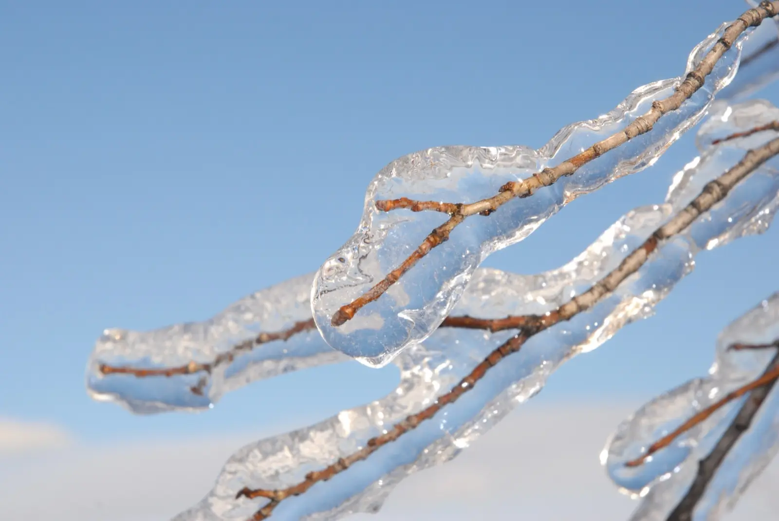
Cover image: Freezing rain glaze on a tree branch. Photo by Velatrix via Wikimedia Commons, CC0 (public domain dedication).
Frequently asked questions
What is the difference between freezing rain and sleet?
Sleet is snow that partly melts in a warm layer and refreezes into ice pellets before landing. Freezing rain melts completely and falls as liquid through a thin cold layer, then freezes on contact with surfaces at or below 32°F, forming a glaze.
Is sleet or freezing rain more dangerous?
Freezing rain is more dangerous for trees and power lines because the ice sticks and builds up. Both make roads very slick, and a storm that changes from sleet to freezing rain is especially hazardous.
What is the difference between sleet and hail?
Sleet forms in winter storms when snowflakes partly melt and refreeze. Hail forms inside thunderstorm updrafts, where raindrops are carried into very cold air, freeze and grow, so hail usually falls in spring and summer.
What temperature does freezing rain happen at?
Freezing rain falls as liquid from a warm layer aloft and freezes on surfaces that are at or below 32°F (0°C). The surface temperature, including pavement, is what matters.
How much ice causes an ice storm warning?
The NWS usually issues an Ice Storm Warning for ice accumulation of around 1/4 inch or more, which can snap power lines and bring down tree branches.
What is the Sperry-Piltz Ice Accumulation Index?
It is a 0 to 5 scale introduced in 2007 that predicts damage to power lines and trees from forecast ice accumulation and wind. Level 5 means catastrophic damage with outages that could last weeks.
What does freezing rain look like?
It looks like ordinary rain while it falls, but it leaves a clear, glassy coating of ice on cars, roads, branches and wires.
Does freezing rain melt snow?
Freezing rain falls at or below the freezing point at the surface, so it tends to freeze onto the snow and form an icy crust rather than melt it.
Sources
- NOAA National Severe Storms Laboratory – Winter Weather Types
- NOAA National Severe Storms Laboratory – Hail Basics
- National Weather Service – Winter Weather Warnings, Watches and Advisories
- National Weather Service – Ice Storms
- National Weather Service – What to do if you're caught in a winter storm
- NWS Chicago – February 11-12, 2019 ice storm
- NWS Service Change Notice 26-52 – PDS wording in Blizzard and Ice Storm Warnings
- Wikipedia – Sperry–Piltz Ice Accumulation Index
- SPIA Index
Log in to comment
No comments yet. Be the first.