Polar Vortex and Bomb Cyclone Explained: What They Are and the Biggest U.S. Events
- The polar vortex always exists; it sits in the stratosphere about 10 to 30 miles above the North Pole.
- Disruptions called sudden stratospheric warmings happen about every other year and can lead to Arctic outbreaks weeks later.
- Bombogenesis: pressure falls at least 24 mb in 24 hours at 60°N, about 17.8 mb near New York City's latitude.
- Notable events include January 2019 (O'Hare −23°F), February 2021 in Texas and Winter Storm Elliott in December 2022.
- A polar vortex disruption cannot be forecast months ahead; NOAA favors a warmer north this winter.
- What is the polar vortex?
- How a disrupted polar vortex sends Arctic air south
- What is a bomb cyclone? The bombogenesis definition
- Is a bomb cyclone the same as a nor'easter or a blizzard?
- Notable U.S. polar vortex and bomb cyclone events
- Will there be a polar vortex in winter 2026–27?
- Is climate change making polar vortex events more common?
- How to prepare when a polar vortex or bomb cyclone is forecast
This article is part of the 77.today Winter Weather Guide 2026–27, prepared by the 77.today editors from the sources listed at the end.
Two phrases take over the headlines every cold season: polar vortex and bomb cyclone. Both sound like science fiction, both are real meteorology, and both are often misused. This part of our Winter Weather Guide 2026–27 explains what the polar vortex actually is, why a weakened vortex can send Arctic air into Chicago, Dallas or Atlanta, what makes a storm a "bomb" (the official bombogenesis threshold, adjusted for latitude), and the notable U.S. events that made both terms famous, from the 2014 cold wave to the January–February 2026 outbreak.
What is the polar vortex?
The National Weather Service describes the polar vortex as "a large area of low pressure and cold air surrounding both of the Earth's poles." It always exists. It weakens in summer, strengthens in winter, and the word "vortex" refers to the counterclockwise flow of air that helps keep the coldest air near the pole. The NWS stresses three things the polar vortex is not: it is not new, it is not a storm, and it is not a feature at the Earth's surface. Forecasters study it tens of thousands of feet up.
NOAA's Climate.gov goes into more detail. The Arctic polar vortex is a band of strong westerly winds in the stratosphere, roughly 10 to 30 miles above the North Pole, that encloses a large pool of extremely cold air. The stronger those winds, the more the cold air inside is isolated from the rest of the hemisphere.
People often confuse it with the polar jet stream, which sits lower, in the troposphere, about 5 to 9 miles up. The jet stream marks the boundary between cold polar air and milder mid-latitude air, and it drives our day-to-day weather. The two can interact, and that interaction is what matters for your winter.
How a disrupted polar vortex sends Arctic air south
When the vortex is strong and stable, the jet stream tends to stay farther north with a flatter, west-to-east flow, and the coldest air stays bottled up in the Arctic. According to Climate.gov, the vortex is occasionally knocked off balance when strong atmospheric waves from below break upward into the stratosphere. The vortex slows down and can wobble, slide off the pole, split into pieces or, in extreme cases, briefly reverse direction. Each of these disruptions comes with a sharp spike in stratospheric temperature, which is why they are called sudden stratospheric warmings.
In the weeks that follow, the jet stream often becomes very wavy, with deep troughs and tall ridges that can stall for days. Arctic air pours south under the troughs, and warmth floods into parts of the Arctic under the ridges. NOAA stratosphere expert Amy Butler told Climate.gov that disruptions happen on average about every other year in the Arctic, and most of the time some part of the mid-latitudes ends up with a cold air outbreak, though not always North America.
Two caveats are important. First, plenty of Arctic cold snaps happen without any help from the polar vortex, and Climate.gov has repeatedly written that the vortex gets blamed for cold it did not cause. Second, a strong vortex matters too: during intensification events the jet stream tends to stay north, which can mean a milder pattern for much of the mid-latitudes. When you see "polar vortex" in a forecast, the useful question is not "is it coming?" but "how cold will it get here, and for how long?"
What is a bomb cyclone? The bombogenesis definition
A bomb cyclone is a mid-latitude storm that strengthens extremely quickly. The technical term is bombogenesis. NOAA's National Ocean Service defines it as a mid-latitude cyclone that rapidly intensifies over a 24-hour period, measured by a drop in central pressure. The lower the pressure, the stronger the storm and its winds.
The threshold depends on latitude. At 60 degrees latitude, the storm's pressure must drop at least 24 millibars in 24 hours. At the latitude of New York City, NOAA says the required drop is about 17.8 millibars in 24 hours. The criterion comes from a 1980 study by meteorologists Frederick Sanders and John Gyakum, who scaled the 60°N threshold by the sine of the latitude, because the same pressure change means a more intense storm closer to the equator. Using that scaling, the approximate thresholds look like this (our calculation, rounded):
| Latitude | Example location | Pressure drop needed in 24 hours (approx.) |
|---|---|---|
| 30°N | Gulf Coast | about 14 mb |
| 35°N | North Carolina coast | about 16 mb |
| 40°N | New York City area | about 18 mb (NOAA: 17.8 mb) |
| 45°N | Maine, Minnesota | about 20 mb |
| 50°N | Southern Canada | about 21 mb |
| 60°N | Reference latitude | 24 mb |
According to NOAA, bombogenesis can happen when a cold air mass collides with a warm air mass, such as air over warm ocean waters, which is why many bombs develop off the East Coast in winter. They also form over the Plains and the Pacific. "Bomb cyclone" is a statement about how fast the storm intensified, not about what it brings, so a bomb can produce a blizzard, an ice storm, hurricane-force wind, coastal flooding or mostly rain, depending on where you are.
The polar vortex is a huge, permanent circulation of cold air over the Arctic; when it is disrupted, Arctic air can spill south for days or weeks. A bomb cyclone is a single storm whose central pressure drops very fast, roughly 24 millibars in 24 hours at 60°N, bringing wind, snow and coastal flooding. One brings the cold; the other brings the storm. Sometimes they arrive together.
Is a bomb cyclone the same as a nor'easter or a blizzard?
Not necessarily. A nor'easter is a storm named for the northeast winds it drives into the Northeast coast; some nor'easters become bombs and many do not. A blizzard is defined by wind and visibility on the ground (frequent 35 mph gusts and visibility under 1/4 mile for three hours, as explained in our part on winter storm warnings vs. watches). A bomb cyclone can create blizzard conditions because rapidly falling pressure creates strong winds, but the terms describe different things: one is the storm's development, the other the conditions it creates.
The NWS does not issue "bomb cyclone warnings." Your local forecast office will issue winter storm, blizzard, high wind or coastal flood alerts based on the impacts expected where you live.
Notable U.S. polar vortex and bomb cyclone events
The NWS notes that the January 2014 cold outbreak that made the term "polar vortex" famous was similar to many earlier outbreaks, including several colder ones in 1977, 1982, 1985 and 1989. Here are the events most often cited since then:
| Event | Dates | Type | What happened (from sources listed below) |
|---|---|---|---|
| Early 2014 cold wave | January–March 2014 | Polar vortex outbreak | Brought the term 'polar vortex' into everyday use; Arctic air reached from the Rockies to the Atlantic |
| 'Bomb cyclone' nor'easter | January 3–5, 2018 | Bomb cyclone | Deepened 53 mb in 21 hours to about 952 mb off the East Coast; up to 2 feet of snow |
| Upper Midwest cold wave | January 29–31, 2019 | Polar vortex outbreak | O'Hare −23°F with a −52°F wind chill on Jan. 30; Rockford all-time low −31°F |
| Plains 'bomb cyclone' blizzard | March 13–14, 2019 | Bomb cyclone | Pressure fell more than 24 mb in 24 hours; all-time low pressure records in Colorado, Kansas and New Mexico |
| Texas winter storm | February 13–19, 2021 | Polar vortex disruption | DFW −2°F on Feb. 16 and 139 straight hours below freezing; 246 deaths in Texas |
| Winter Storm Elliott | December 21–26, 2022 | Bomb cyclone + Arctic outbreak | Pressure fell about 35 mb; Buffalo blizzard with 56+ inches of lake-effect snow; at least 100 deaths |
| January–February 2026 cold wave | January 17–February 11, 2026 | Polar vortex after a sudden stratospheric warming | Chicago −11°F with −36°F wind chill on Jan. 23; snow reached Texas and Florida |
January 2014: the polar vortex goes mainstream
In early January 2014, an Arctic front swept across Canada and the United States behind a nor'easter, followed by a southward shift of the polar vortex. Record lows, school and road closures and mass flight cancellations followed, and the cold persisted into March. The phrase "polar vortex" entered everyday language that winter.
January 2018: the "historic bomb cyclone"
A storm that formed off the Southeast coast on January 3, 2018, deepened by 53 millibars in 21 hours to a pressure of about 952 millibars, one of the fastest rates of intensification observed in the western Atlantic. It brought blizzard warnings from Norfolk, Virginia, to Maine, up to two feet of snow in the Mid-Atlantic and New England, and even a tenth of an inch of snow in Tallahassee, Florida.
January 30, 2019: record cold in the Midwest
A weakened polar vortex sent the coldest air in more than 20 years into the Midwest. Chicago O'Hare fell to −23°F on January 30 with a wind chill of −52°F, and Rockford, Illinois, set an all-time record low of −31°F. Cotton, Minnesota, near Duluth, hit −56°F, the coldest reading in the country.
March 2019: a bomb over the Plains
A powerful Colorado low in March 2019 dropped more than 24 millibars in 24 hours, set all-time low pressure records in Colorado, Kansas and New Mexico, produced up to two feet of snow and hurricane-force gusts, and its rapid snowmelt fed historic flooding in the central U.S.
February 2021: Texas
Climate.gov reported that a sudden stratospheric warming in January 2021 weakened and displaced the polar vortex, encouraging a deep plunge of the jet stream into the south-central U.S. in mid-February. Dallas/Fort Worth hit −2°F on February 16 and, according to NWS Fort Worth, spent 139 consecutive hours below freezing from February 13 to 19. More than 4.5 million homes and businesses in Texas lost power, and the Texas Department of State Health Services put the death toll at 246.
December 2022: Winter Storm Elliott
Between December 23 and 24, 2022, the storm's pressure fell about 35 millibars as it moved from Indiana into Ontario, well beyond the bomb threshold, and an Arctic outbreak followed. Buffalo, New York, had two days of zero-visibility blizzard conditions and more than 56 inches of lake-effect snow over five days. The storm and cold killed at least 100 people, 41 of them in the Buffalo area.
January–February 2026: the most recent major outbreak
After a sudden stratospheric warming at the start of 2026, the polar vortex shifted south and a long cold wave gripped much of North America from mid-January into February 2026. The NWS in Chicago recorded −11°F with a wind chill of −36°F on January 23, and NASA's Earth Observatory documented frigid air lingering across a vast swath of the country after a major winter storm. Snow reached as far south as Texas and Florida.
Will there be a polar vortex in winter 2026–27?
The vortex itself will form again this winter, as it does every year. Whether it will be disrupted, and where the cold will go if it is, cannot be forecast months ahead. Even when a disruption happens, its effect at the surface is uncertain. NOAA's official seasonal outlook, issued October 15, 2026, favors a warmer-than-average winter across the northern U.S. because of a very strong El Niño, but a seasonal average still allows for short, intense Arctic outbreaks. Our winter forecast 2026–27 part covers the outlook in detail.
For live updates, NOAA's Climate.gov runs a dedicated polar vortex blog during the cold season, and the NWS Climate Prediction Center publishes 6–10 day, 8–14 day and week 3–4 outlooks that will show any Arctic outbreak well before it arrives.
Is climate change making polar vortex events more common?
The honest answer is that scientists do not agree yet. According to Climate.gov, the observational record of the stratosphere only goes back to the 1950s. There were no sudden stratospheric warmings in the Arctic during much of the 1990s, then they returned with one almost every year for about a decade, which briefly looked like a trend. Some high-resolution climate models predict a weaker, more disrupted vortex as Arctic sea ice declines; other simulations predict a stronger vortex. The "models stubbornly split," as Climate.gov put it, so be skeptical of any headline that claims a settled answer either way.
How to prepare when a polar vortex or bomb cyclone is forecast
- For an Arctic outbreak: learn the wind chill chart and frostbite times, protect your pipes, check on older neighbors and bring pets inside. Watch for Extreme Cold Watches and Warnings.
- For a bomb cyclone: expect strong wind and possible power outages in addition to snow, ice or coastal flooding. Charge devices, secure outdoor objects and follow your local NWS office's alerts.
- For both: our winter storm preparedness checklists cover home kits, car kits, generators and carbon monoxide safety.
Return to the Winter Weather Guide hub for all seven parts. Polar winters also bring the best aurora seasons at high latitudes; check the northern lights forecast or our night sky guide.
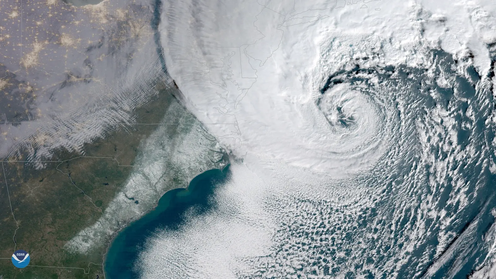
Cover image: NOAA GOES-East satellite view of the powerful nor'easter ("bomb cyclone") off the U.S. East Coast on January 4, 2018. Image: NOAA/NESDIS via Wikimedia Commons, public domain (U.S. government work).
Frequently asked questions
What is a polar vortex?
It is a large area of low pressure and very cold air that always surrounds the poles, with a band of strong westerly winds in the stratosphere about 10 to 30 miles up. When it is disrupted, Arctic air can spill south into the U.S.
What causes a polar vortex to weaken?
Strong atmospheric waves from the lower atmosphere can break upward into the stratosphere and slow the vortex, causing it to shift, stretch or split. These events are called sudden stratospheric warmings.
What is a bomb cyclone?
A mid-latitude storm that intensifies rapidly, with central pressure falling at least 24 millibars in 24 hours at 60 degrees latitude, or about 17.8 millibars at New York City's latitude. The process is called bombogenesis.
When was the last polar vortex in the U.S.?
The most recent major outbreak linked to the polar vortex ran from mid-January into February 2026, after a sudden stratospheric warming at the start of the year. Chicago hit −11°F with a −36°F wind chill on January 23, 2026.
How cold did Chicago get during the 2019 polar vortex?
O'Hare International Airport fell to −23°F on January 30, 2019, with a wind chill of −52°F. Rockford, Illinois, set an all-time record low of −31°F.
Will there be a polar vortex in winter 2026–27?
The vortex forms every winter, but whether it will be disrupted cannot be predicted months ahead. NOAA's October 2026 outlook favors a warmer-than-average northern U.S. because of a very strong El Niño, which still allows short Arctic outbreaks.
Is a bomb cyclone the same as a blizzard?
No. A bomb cyclone describes how fast a storm strengthens. A blizzard describes conditions on the ground: frequent 35 mph gusts and visibility under 1/4 mile for three hours. A bomb can produce a blizzard, but not always.
Is the polar vortex dangerous?
The vortex itself is high in the atmosphere. The danger is the extreme cold that can reach the surface when it is disrupted, which can cause frostbite, hypothermia, burst pipes and power grid stress.
Sources
- National Weather Service – What is the Polar Vortex?
- NOAA Climate.gov – Understanding the Arctic polar vortex
- NOAA Climate.gov – Polar vortex intensifications
- NOAA National Ocean Service – What is bombogenesis?
- Wikipedia – Explosive cyclogenesis (Sanders and Gyakum 1980 definition)
- NWS Fort Worth – DFW freeze summary
- NWS Chicago – January 23-24, 2026 bitterly cold temperatures
- NASA Earth Observatory – Extreme January Cold (2026)
- Wikipedia – January–February 2026 North American cold wave
- Wikipedia – January–February 2019 North American cold wave
- Wikipedia – 2021 Texas power crisis
- Wikipedia – January–March 2014 North American cold wave
- Wikipedia – January 2018 North American blizzard
- Wikipedia – March 2019 North American blizzard
- Wikipedia – December 2022 North American blizzard
Log in to comment
No comments yet. Be the first.