Winter Forecast 2026–2027: NOAA's Official Outlook, El Niño and What the Almanacs Say
- NOAA (Oct. 15, 2026): warmer than average favored across the northern U.S. and Alaska; wetter across the southern tier and East Coast.
- Near-normal temperatures most likely in parts of the Southeast including Florida; equal chances in much of the Southwest.
- CPC (Oct. 8, 2026): El Niño Advisory; strong-to-very strong El Niño likely through January–March 2027.
- NOAA does not forecast seasonal snowfall; snow is not predictable more than about a week ahead.
- The almanacs use undisclosed formulas; NOAA publishes probabilities and updates monthly (next Nov. 19).
- What NOAA's official winter outlook says
- Temperature outlook by region
- Precipitation and drought outlook
- El Niño or La Niña? The current ENSO status
- What El Niño usually means for a U.S. winter
- How the Farmers' Almanac and Old Farmer's Almanac differ from NOAA
- How to read NOAA's outlook map
- When the outlook will be updated, and better tools for the actual winter
- What the 2026–27 outlook means for you
This article is part of the 77.today Winter Weather Guide 2026–27, prepared by the 77.today editors from the sources listed at the end.
NOAA released its official U.S. Winter Outlook for 2026–27 on October 15, 2026, and the headline is clear: a very strong El Niño is expected to dominate the season, with a warmer-than-average northern tier and a wetter, stormier South and East Coast. This part of our Winter Weather Guide 2026–27 explains what the official winter forecast 2026 actually says region by region, the latest El Niño status from the Climate Prediction Center, why this is not a La Niña winter despite what some older articles suggest, and how the Farmers' Almanac winter 2026–27 forecasts differ from NOAA's. We do not invent snowfall totals; neither does NOAA.
What NOAA's official winter outlook says
NOAA's Climate Prediction Center (CPC) issues the official seasonal outlook for meteorological winter, December 2026 through February 2027. According to NOAA's announcement, El Niño will likely bring "warmer-than-average temperatures expected across the northern U.S.; wetter-than-average conditions likely across the southern U.S., from California to Florida, and along the Eastern Seaboard; and drought improving for the majority of the country."
Ken Graham, director of NOAA's National Weather Service, explained the reasoning: "a very strong El Niño will likely bring a southward and eastward shift to the jet stream for the contiguous U.S., which tilts the odds toward stormier weather across the South." He added that while more rain and snow could ease drought, "too much precipitation on dry soil can fuel destructive flash floods and mudslides."
Temperature outlook by region
| Region | NOAA temperature outlook, Dec 2026–Feb 2027 |
|---|---|
| Pacific Northwest, northern California | Warmer than average favored |
| Northern Rockies, northern Plains | Warmer than average favored |
| Midwest, Great Lakes, Mississippi Valley | Warmer than average favored (among the highest odds on the map) |
| Northeast, New England, much of the East | Warmer than average favored |
| Southeast including Florida (parts) | Near-normal most likely |
| Much of the Southwest | Equal chances of below, near or above average |
| Alaska | Warmer than average favored |
| Hawaii | Equal chances |
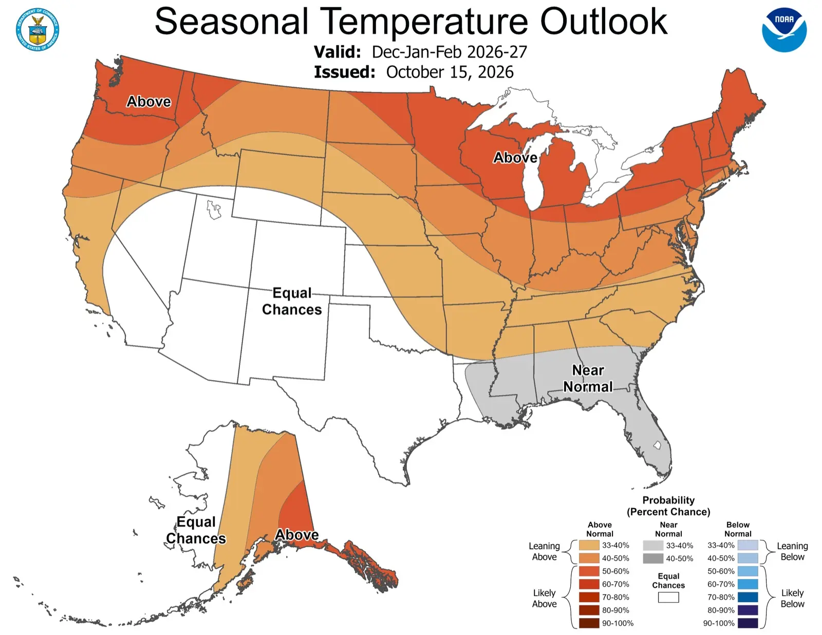
On the official CPC map, the highest odds for a warmer-than-average winter, in the 50 to 60 percent range, cover the Pacific Northwest, the Upper Midwest and Great Lakes, and the Northeast and New England, with lower "leaning above" odds across the central states and the South. NOAA notes that near-normal temperatures are most likely for parts of the Southeast including Florida, and that much of the Southwest has equal chances. Puerto Rico and the U.S. Virgin Islands also lean warmer than average.
Precipitation and drought outlook
| Region | NOAA precipitation outlook, Dec 2026–Feb 2027 |
|---|---|
| Southern tier, from the Southwest and California to the Southeast and Florida | Wetter than average favored |
| East Coast | Wetter than average favored |
| Northern Mountain West, northern Rockies | Drier than average favored |
| Some areas of the Great Lakes | Drier than average favored |
| Much of Alaska, Hawaii | Drier than average favored |
| Intermountain West, northern Plains, Ohio Valley | Equal chances |
NOAA's drought outlook, running from October 15, 2026, through January 2027, expects drought to improve or end in the Southwest, the Southern Great Plains, the Southeast and parts of the East Coast. Drought is favored to develop or worsen across parts of the northern Rockies, northeastern Oregon and eastern Washington.
What about snow? NOAA is explicit that the outlook "does not project seasonal snowfall accumulations as snow forecasts are generally not predictable more than a week in advance." A wetter South can mean heavy snow in the southern Rockies or an ice storm in Texas during a cold spell, and a warmer North can still have big snowstorms. Anyone selling you a precise "2026–27 snow total" for your town is guessing.
A NOAA seasonal outlook is about odds for a three-month average, not a daily forecast. A 50 percent chance of a warmer-than-average winter still leaves room for a brutal cold week, a blizzard or an ice storm. Use the outlook to plan budgets and supplies; use the 7-day forecast and NWS watches and warnings to plan your actual days.
El Niño or La Niña? The current ENSO status
Many people are searching for "La Niña winter 2026," a hangover from last winter, when the NWS expected La Niña to persist into the 2025–26 season. For 2026–27 the situation has flipped. In its ENSO Diagnostic Discussion of October 8, 2026, the CPC kept an El Niño Advisory in place and wrote that "El Niño continues to strengthen, with a strong-to-very strong El Niño likely through January-March 2027 (remaining greater than an 83% chance)."
The numbers behind that statement are unusual. The CPC reported sea surface temperature anomalies exceeding +4.0°C in parts of the eastern equatorial Pacific, with the key Niño-3.4 index at +2.1°C, Niño-3 at +3.0°C and Niño-1+2 at +3.9°C. It put the chance of a "historic" event, stronger than any El Niño on record since 1950 (a three-month value of +2.5°C or more), at 54% for September–November, 83% for October–December and 70% for November–January. The CPC also cautioned that a strong event raises the chances of typical El Niño impacts but does not guarantee them. The next ENSO discussion is scheduled for November 12, 2026.
So the short answer: winter 2026–27 is an El Niño winter, not a La Niña winter.
What El Niño usually means for a U.S. winter
El Niño is a periodic warming of the central and eastern tropical Pacific that reshapes atmospheric circulation worldwide. For the United States, NOAA says a strong El Niño tends to shift the jet stream south and east. That typically means:
- More storms across the southern tier, from California and the Southwest through Texas and the Gulf Coast to Florida.
- A milder, often less snowy North, especially the northern Plains, Upper Midwest and Pacific Northwest, as NOAA's temperature map reflects.
- An active East Coast, where NOAA favors a wetter winter. Whether that falls as rain, snow or ice depends on cold air being in place for each storm.
Two cautions. First, El Niño loads the dice; it does not decide every week of the winter. Arctic outbreaks can still happen, particularly if the polar vortex is disrupted, and that cannot be predicted months ahead. Second, no two El Niño winters are identical; the seasonal outlook already reflects how strong El Niño years have behaved in the past.
How the Farmers' Almanac and Old Farmer's Almanac differ from NOAA
Two different almanacs publish winter forecasts every year, and they are often confused.
The Farmers' Almanac (founded in 1818) announced in 2025 that its 2026 edition would be its last. That farewell turned out not to be final: the publication says it now continues under new ownership, its website is active, and the 2027 Farmers' Almanac is its 210th edition. Its 2026–27 winter outlook, credited to its pseudonymous forecaster "Caleb Weatherbee," calls for a winter of "snow, sleet, and surprises": an active, wet storm track across the southern tier, near-normal temperatures with quick cold snaps across the West, northern Plains, Upper Midwest and Great Lakes, a tricky rain-snow-ice mix for the Northeast, and a changeable season in the Northwest. It says its method is a proprietary formula based on recurring natural cycles, solar activity, lunar influences and historical patterns, now combined with modern tools. The Almanac reports 80–85% accuracy on regional outlooks, while acknowledging in its own FAQ that independent reviews put actual accuracy somewhat lower.
The Old Farmer's Almanac (published since 1792) posted its 2026–27 U.S. winter forecast on October 8, 2026, under the headline "Mostly Mild Winter — Colder, Snowier Spots Ahead!" Its full 12-month forecast is in the 2027 edition. It describes its method as a formula combining solar science, climatology and meteorology with historical weather patterns and large-scale climate signals.
| NOAA Climate Prediction Center | Farmers' Almanac (since 1818) | The Old Farmer's Almanac (since 1792) | |
|---|---|---|---|
| Who makes it | Government meteorologists | Forecaster under the pen name Caleb Weatherbee | Almanac editors and forecasters |
| Method | Dynamical climate models, statistical tools, ENSO and trends; published methodology | Proprietary formula (sunspots, lunar position, tidal pull, historical patterns) plus modern tools; details not published | Formula combining solar science, climatology and meteorology; details not published |
| Output | Probabilities of above, near or below normal temperature and precipitation | Descriptive regional outlook (storms, cold snaps, snow) | Regional forecast with snowiest periods |
| Issued | October 15, 2026; updated monthly (next Nov. 19) | Published August 2026, updated online | Online October 8, 2026; full 12-month forecast in the 2027 edition |
| Snowfall totals | Not forecast (not predictable more than about a week ahead) | Descriptive only | Descriptive only |
| 2026–27 headline | Warmer North, wetter South and East | 'Snow, sleet and surprises'; wet, stormy southern tier | 'Mostly mild winter — colder, snowier spots ahead' |
The main difference is transparency and format. NOAA publishes probabilities from documented models and verifies them; the almanacs publish descriptive forecasts made with methods they do not fully disclose, months before the season. Interestingly, both almanacs' 2026–27 outlooks broadly echo the El Niño pattern (a stormy South and a mild-leaning North), which NOAA had been signaling since El Niño formed. Read them for fun and tradition; plan with NOAA and your local NWS office.
How to read NOAA's outlook map
The CPC maps are easy to misread. They do not show how much warmer or wetter it will be; they show the probability that the three-month average will fall in one of three categories: above normal, near normal or below normal. Each category has a one-in-three chance in an average year, so any shaded area is a place where forecasters see a tilt in the odds.
- Leaning above (33–40% and 40–50%): a modest tilt toward a warmer or wetter season.
- Likely above (50% and higher): a stronger signal. On the 2026–27 temperature map, the darkest shading in the lower 48 is in the 50 to 60 percent range.
- Near normal (gray): the middle category is favored, as in parts of the Southeast this winter.
- Equal chances (white): no category is favored. This does not mean "normal weather"; it means the forecast tools do not give a useful signal there.
Even a 60 percent chance of a warmer-than-average winter leaves a 40 percent chance of a near-normal or colder one. That is why NOAA pairs the outlook with a reminder to keep checking the latest watches and warnings on weather.gov all season.
When the outlook will be updated, and better tools for the actual winter
NOAA updates its three-month outlook monthly; NOAA says the next update will be available on November 19, 2026. Closer to each storm, use shorter-range products:
- CPC 6–10 day, 8–14 day and week 3–4 outlooks show whether a cold or stormy pattern is coming in the next few weeks.
- The NWS Probabilistic Precipitation Portal, operational this winter, shows low-end, expected and high-end snow and ice amounts for individual storms.
- Local NWS watches, warnings and advisories, explained in our part on winter storm warnings vs. watches.
What the 2026–27 outlook means for you
- Northern tier: odds favor a milder winter on average, but do not skip winter preparation. Short Arctic blasts and lake-effect snow remain possible. Know the wind chill chart.
- South and Southwest: expect more storms. In cold spells, that moisture can become snow or freezing rain and sleet in places that rarely see it, and heavy rain on dry ground raises flash flood risk.
- East Coast: a wetter winter is favored, so coastal storms and nor'easters are worth watching; whether they bring rain or snow will be decided storm by storm.
- Everyone: build your kits now with our winter storm preparedness checklists, and if you have school-age kids, read how snow days are decided.
Return to the Winter Weather Guide hub for the full series.
Cover image: NOAA Climate Prediction Center seasonal temperature outlook for December 2026 to February 2027, issued October 15, 2026. Image: NOAA via noaa.gov, public domain (U.S. government work).
Frequently asked questions
What is the NOAA winter forecast for 2026–2027?
NOAA's outlook, released October 15, 2026, favors warmer-than-average temperatures across the northern U.S. and Alaska, wetter-than-average conditions across the southern tier and East Coast, and improving drought for much of the country.
Is winter 2026–27 a La Niña or El Niño winter?
El Niño. The CPC's October 8, 2026, discussion keeps an El Niño Advisory and says a strong-to-very strong El Niño is likely through January–March 2027.
Will it be a snowy winter in 2026–27?
NOAA does not forecast seasonal snowfall because snow is generally not predictable more than a week ahead. A wetter South and East raise storm chances, but snow depends on cold air being in place for each storm.
What does the Farmers' Almanac predict for winter 2026–27?
The Farmers' Almanac calls for 'snow, sleet, and surprises': a wet, stormy southern tier, quick cold snaps in the North and a tricky rain-snow-ice mix in the Northeast. Its method is a proprietary formula that is not published.
Is the Farmers' Almanac still being published?
Yes. Its previous owners said in 2025 that the 2026 edition would be the last, but the Almanac says it continues under new ownership and the 2027 edition is its 210th.
How accurate is the Farmers' Almanac compared with NOAA?
The Farmers' Almanac reports 80–85% accuracy but acknowledges independent reviews put it lower, and its method is not disclosed. NOAA publishes probabilistic outlooks from documented models and updates them monthly.
When will NOAA update the winter outlook?
NOAA updates its three-month outlook monthly. The next update after October 15, 2026, is scheduled for November 19, 2026.
What does a strong El Niño mean for winter in the U.S.?
It tends to shift the jet stream south and east, favoring stormier, wetter weather across the South and milder conditions across the northern U.S., though it does not rule out Arctic outbreaks.
Sources
- NOAA – El Nino looms large over U.S. Winter Outlook (Oct. 15, 2026)
- NOAA – Media advisory: 2026-2027 U.S. Winter Outlook
- NOAA Climate Prediction Center – Seasonal outlook, Dec-Jan-Feb
- NOAA Climate Prediction Center – ENSO Diagnostic Discussion (Oct. 8, 2026)
- NOAA – El Nino forms, expected to strengthen
- NWS La Crosse – Winter 2025-26 Outlook (La Niña)
- USA Today – Winter weather forecast released by NOAA for 2026-2027
- Farmers' Almanac – 2026/2027 Winter Weather Forecast
- Farmers' Almanac – An update to our readers (new ownership)
- The Old Farmer's Almanac – Winter Forecast 2026–2027
- NOAA Weather Prediction Center – Probabilistic Precipitation Portal
Log in to comment
No comments yet. Be the first.